The technical approach in this project recognises Land Use as a complex, coupled social ecological system with both biophysical and socio-technical components that need to be better understood if the objectives of public policy and wider society are to be delivered. Land Use Science is a form of interdisciplinary research that uses a wide range of natural, social and computational research methods to address issues of interest to wider society (i.e. Mode 2 interdisciplinarity). The research is systems focussed and integrative, with new combinations of well-established Hutton research teams co-operating to generate insights by synthesis-ing and exploiting data, tools and knowledge from within the Land Use Topic, with other SRP Topic teams and with a community of practice for science-policy.
The proposed research is underpinned and shaped by a broad range of disciplines most influentially socio-ecological systems, societal metabolism, multi-scale integrated assessment and new approaches to environmental governance. Governance requires attention to the social actors, the structures or institutions involved in LU/LUC, and their interactions across administrative and territorial levels, and between regional and local groups. Increasingly, the inclusion of the private sector actors and institutions (e.g., value chains or investment markets) is recognised in having impacts on governance outcomes. ‘Meaning-making’ matters in governance processes, reflecting the increased interest in story-telling shaping social change. The proposed research will build on studies of joined-up public and private implementation practices, combined with multiple understand-ings of Land Use and Land Use change across levels (national, regional, local) and between different social actors (policy, land manager, residents, visitors) expressed through story-telling. These perspectives affect how legitimacy is negotiated in governance yet are often considered separately to policy coherence analysis.

The systems research will draw on an extensive catalogue of integrated geospatial data combining climate/climate change, soil, land cover, use and management data, farm structure and a wide range of other administrative data such as (IACS farm payments, AgCensus and harvested yields). The research can make use of a range of remotely sensed data (e.g, the Landsat, MODIS and Sentinel data catalogue, to derive indices of ecosystem productivity, soil moisture, vegetation greenness and to integrate EO and ground data to improve estimation of soil properties at unsampled locations) and the emerging remote-sensing based datasets such as the NatureScot Land Cover and RESAS Crop maps. The analysis will use a range of simulation models including crop and farm systems models such as DSSAT and APSIM, INVEST (a suite of models used to quantify multiple ecosystem services) and the APoLUS land use change model, and dynamic models that assess the likely change in species diversity and habitat connectivity caused by different scenarios of land use change. The research will make use of machine learning and sparse data modelling methods and will be able to draw on other advanced statistical analysis and modelling methods through cooperation with BioSS. The quantities of data generated by these approaches means there is a need for graphical and map-based visualisations and summary dashboards or other presentations of options for their comparisons. This will build on expertise in participatory and deliberative processes developed across multiple science-policy and science-stakeholder projects.
Central to integrative land use science are deliberative inclusive processes, whereby participants not only provide data but interpret and act on the implications of such data. Within literature on Science-Policy interfaces, there is increasing attention to how knowledge is used and the importance of iterative research cycles to improve transdisciplinary engagement. These processes require attention to representation and legitimacy, social processes and the lived experiences of their outcomes, helping to update Kingdon’s policy change model with closer attention to environmental justice.
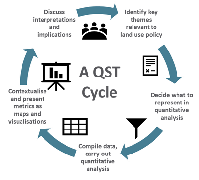
The research will be policy-relevant, and where appropriate, policy-led. The project seeks to deliver a range of impacts with, and for, stakeholders through transdisciplinary working, contributing to ongoing policy and other stakeholder processes. The specific approach to transdisciplinarity proposed for this project is Quantitative Story Telling (QST) developed and tested in the H2020 MAGIC project. QST will be used to support social learning regarding governance in complexity (multiple land use sectors, multiple objectives, multiple scales). The QST approach (illustrated in Figure 1) is typically conducted in cycles that combine semantic (qualitative) analysis and formal (quantitative) analysis. This recognises that issue framing and the interpretation of outputs can have a profound influence on what is analysed (or excluded), how it is analysed and what impact the research can have.
